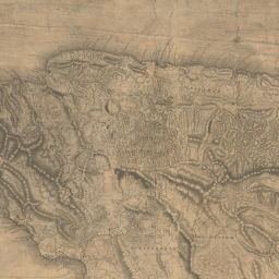
Jamaica
The map of Jamaica was produced by James Robertson from land surveys of Jamaica between 1796 and 1799 and published in 1804. It has been georeferenced by the Map Collections team at the National Library of Scotland , allowing a smooth transfer between the 1804 map and a modern satellite image.
There are 814 sugar plantations on Robertson's map and all have been linked to estates in the LBS database. Sugar mills on the map are distinguished by power source, whether wind cattle or water. There are a further c. 2,500 pens or non- sugar plantations, identified by the small rectangular boxes on the map, which we have not yet linked to the LBS database. Our estates search form allows you to find the 5898 Jamaican estates in the LBS database which have not been linked to the map, as well as the 850 which have. See our Notes on Sources for more information on the sources used.
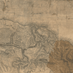
Barbados
In 1812, Francis Louis Barrallier was ordered to undertake an elaborate military survey of Barbados. The work took him five years. The edition used on this website is that of 1825 and is a digital copy of the map held by the National Archives .
Barrallier identified 416 estates and their owners on a map striking for both its detail and the clarity of its image. The locations of 110 estates given on the map have been linked into the estate details in the database.
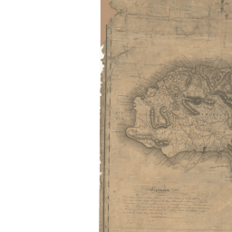
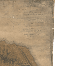
Grenada
This map of Grenada was published in 1780 with the title 'A New Plan of the Island of Grenada, From the Original French Survey of Monsieur Pinel; Taken in 1763 by Order of the Government, and now Published with the Addition of English Names, Atlerations of Property and other Improvements to the Present Year 1780...' (British Library Maps K. Top.123.112.b-e). It was compiled by Daniel Paterson (1738-1825), a British army officer better known for his road maps of Britain, and has been georeferenced by members of LBS.
Our work on this map is not yet complete. We have added lists of proprietors found with the map in 1763 and 1780-2 (British Library Maps K. Top.123.112.b-e) and are currently adding those from a list in government dispatches for 1772 (National Archives CO 101/1). Only a few of these estates have so far been linked to estates in the compensation records. Please use our estates search form to find named estates in the slave registers and our main search form to find estates in the compensation records.